(Also see Garden Route Hiking Trails)
The four Trail hiking series are mostly done as Seperate hiking trails but doing it as a series is amazing!
Four Trail hiking series Epic!
Tsitsikamma
Alexandria
Strandloper
Shipwreck
Trail 1: Tsitsikamma
The Tsitsikamma Trail is a hiking paradise, journeying through extensive indigenous afromontane forest and mountain fynbos. Ancient river gorges and abundant rivers and streams remind us of the creative power of water and the origins of the word Tsitsikamma. This is an enchanted world where echoes of past giants such as elephant and buffalo can still be felt. Some of the finest specimens of South Africa’s national tree, the Outeniqua yellowwood, keep sentinel over the forest canopy while hikers clamber over their enormous roots beneath.
Beginning in Nature’s Valley and ending 62.3km further at either the Storms River Bridge or Village, this six day, unidirectional trail takes hikers through the heart of the Tsitsikamma Mountains.


Trail 2: Addo's Alexandria Hiking Trail
Hiking the two-day Alexandria Hiking Trail in Addo Elephant National Park is an unforgettable experience that leads the hiker through three distinctly different environments ranging from forest to coastal dunes, to seashore. No other trail in the country can boast this diversity, as you clamber up the desert-like dunes and stand aloft cliffs crumbling into the sea, trek through high forest, and along spectacular beaches. The trail traverses sand dunes of the largest coastal dune field in the Southern Hemisphere. Fantastic!


On the way to start the Amatola Trail enjoy the rural scenery and the cows. The Amatola Trail is widely regarded as the toughest and one of the most amazing hutted hiking trails in South Africa. A six-day and five-night hike starting at Maden Dam near King Williams Town, traversing the incredible Amatola Mountains and ending in the iconic village of Hogsback.
The Amatola Trail is truly amazing. One of the most beautiful hikes I have ever hiked. I consider it as the Comrades of South Africa’s Hiking Trails 👣

Day 1
Maden Dam – Gwiligwili Hut (11km)
Day 1 is the easiest and Day 1 Maden Dam – Gwiligwili Hut (11km) shortest day of the whole trail, and the only day you don’t need to set off at Daybreak. Dan ftom Away with the Ferries will take you to start at Maden dam and then you climb 700m on the first day. You climb through a beautiful indigenous forest You will notice what looks like fresh dog poo everywhere, it’s digested soil, from giant earthworms and they often grow to 1m in length !
Gwiligwili Hut is perched on top of a hill with views forever and beautiful sunset.
Water: Take 1 liter to 1.5 liter of water with you. There are one or two opportunities on way to fill up at streams
Check out my activity on Strava: https://strava.app.link/3iq05nOkiAb

Day 2
Gwiligwili Hut – Dontsa Hut (18km Or 19.6km)
Day 2 Traverse through indigenous forest the entire distance with the Keiskammahoek valley below. It is a long day of undulations which can be exhausting for the less than fit. Dontsa hut is in one of the few patches of pine plantation that you will pass through. Pine on one side and indigenous forest on the other.
Water: Take enough water with. The water in the streams below Hut 2 is not safe to drink
Check out my activity on Strava: https://strava.app.link/ChYJaiTmiAb


Day 3
Dontsa Hut – Cata Hut (20,62 km 2024m Ascent)
This is a very long tough day, with lots of outstanding views. For the first time you leave the forest behind as the trail ascends to the plateau, where macchia grassland and a myriad of wildflowers grow.
Check out my activity on Strava: https://strava.app.link/fMAYwz8miAb

Check out my activity on Strava: https://strava.app.link/KQSzbnaniAb


Day 5 Mnyameni Hut to Hog 3 (19.42km 991m Ascent)
Check out my activity on Strava: https://strava.app.link/WaP0qrbpiAb

Day 6 Hog 3 to Hogsback (16.2km. 1000m Ascent)
Visit Baines Falls, before setting off on last day of the trail. The trail goes up up up 900m (past the dam and water full up) ascent to Hog 1. At top of the climb you are on the edge of Hog 1 from where you can see the whole route you've hiked and forward to Hogsback. Beautiful!
Check out my activity on Strava: https://strava.app.link/0TCPxGvpiAb


👣👣👣👣👣👣👣👣👣👣👣👣👣👣👣👣👣👣
Table Mountain Excursion (2 Days / 1 night)

Overnight at the Overseers Cottage, located high above Kirstenbosch Botanical Gardens and the Southern Suburbs of the city, overlooking False Bay. By the evening all the day walkers have left, the tranquility and peacefulness is wonderful
Luggage 🧳: Luggage needs to be dropped off at a pre-arranged spot. It will be taken to the Cottage. On day 2 luggage must be fetched at a pre-agreed spot. Only carry a day pack.
Bedlinnen & Towels are provided and included.
Description
Day 1
There are various routes which can be used on day one. Three suggested options: Depending on The groups preferences and abilities.
Option 1: Via Kirstenbosch & Skeleton Gorge
Enjoy a leisurely walk through the Gardens until you reach the contour path, where the mountain hike begins.
Start at Kirstenbosch Botanical Gardens.


Option 2: Via the Pipe Track and Kasteelpoort with lovely views of the Atlantic Coastline. Start at Theresa Avenue in Campsbay


https://strava.app.link/gDSg4DhlbJb
Option 3: Via Constantia Neck via the jeeptrack. Start at Constantia Neck parking.
Whichever route we take, it is great to first explore around the Back of Table Mountain and enjoy lunch somewhere on the back table before heading to the Overseers Cottage in the late afternoon. Visit the railway museum and the old reservoirs. On to Kasteelspoort for the vital photograph of ‘the diving board’ that overlooks Camps Bay and the Atlantic Coastline, far below. In the evening enjoy the fire place, the stars and tranquility on Table Mountain.
The duration of the first days walk to Overseers Cottage depends on the route chosen & fitness levels of the group. It is approximately 4 to 5 hours.
As I always say, the aim is not to get to the hut but to enjoy the hike.
Day 2
There are various routes which can be used on day one. Two suggested options: Depending on The groups preferences and abilities.
Option 1
Set off along the historic Smuts Track towards Skeleton Gorge and Nursery Ravine and Echo Valley, on your way to Maclears Beacon and the highest point of the mountain Enjoy the interesting rock formations, the spectacular views, and the wide variety of fynbos species, including proteas, ericas, restios, and many others. Enjoy lunch on the way to the top of Platteklip Gorge and the Western Table en route to the cable car station. Take money with you for the cable car as it is not included.
The optional alternative is to walk off the Table, down the steep, but well defined Platteklip Gorge route.
The cable car is weather permitting, in which case an alternative route which suits the group will be used for the hike.


https://strava.app.link/133uXKllbJb
Option 2
Set off and follow the route between the dams, Via Waaikoppie to the top of Platteklip Gorge. From here turn left towards the cable car or hike down Platteklip Gorge.


Disas : The Table Mountain National Park is a treasure trove of wildflowers. Plan your trip to see the beautiful Disas on Table Mountain. Three of the disa orchids generally flower between mid-January and the end of March in bloom and they can be found along some of the routes. In November chance are good to spot the Drip Disas in the Aquaduct.
Disa uniflora, the red disa or pride of Table Mountain, is a South African species of orchid in the family Orchidaceae.
The Drip Disa, Longicornu (Orchid family) is listed as Vulnerable and is declining at all of its known localities. Disa Graminifolia (Blue Disa) is not easy to find. Disa Ferruginea (Orange Cluster Disa) is quite common and can very easily be found. Take special care when identifying this flower, since the Tritoniopisis Triticea (Summer Snowflake Iris) is also in bloom at the same time , and the two are often mistaken.

The Cederberg mountains
The Cederberg mountains located near Clanwilliam are . The mountain range is named after the endangered Clanwilliam cedar, which is a tree endemic to the area.
Most of the Cedarberg mountains are part of the official Cederberg Wilderness Reserve and remain one of the most pristine areas of South Africa.
The Cederberg is famous for its spectacular rock formations that were sculpted by wind and water over many millions of years. Almost the entire area consists of sedimentary rock, sandstone and shale. The distinct reddish colour of rock is a result of minerals like iron and manganese that formed part of the sediments. Pristine Fynbos grows here includung various types of Restios and the snow Proteas.
The solitude and breathtaking natural beauty of the area is captivating. A true wilderness experience with dramatic sunsets!


The Rock Pigeon Route in Oorlogskloof Nature
Reserve near Nieuwoudtville in the Northern Cape is one of South Africa’s best multi-day hikes. But it doesn’t come easy.
The five-day, 52km circular trail starts and ends at Groot Tuin, where there’s safe parking for vehicles and an overnight hut. The ablution block wasn’t completed yet so there’s just a long-drop loo. Groot Tuin is the only place where fires are allowed. You receive a detailed map and route description on arrival and there are markings along the trail.


Groot Tuin To Brakwater


The Drakensberg mountains offer a wide range of walking and hiking trails – from the easy strolls around the many resorts, to strenuous hikes to the summit. Waterfalls, rivers, magnificent vistas and places of beauty and solitude are all there to explore. It is magical.


- RAINBOW GORGE NEAR BERGVILLE. ...
- CHAIN LADDERS HIKE IN NORTHERN DRAKENSBERG. ...
- LOWER INJISUTHI CAVE IN INJISUTHI. ...
- CATHEDRAL PEAK – CATHEDRAL RIDGE. ...
- THE MNWENI CIRCUIT IN NORTHERN DRAKENSBERG.
- PLOUGHMAN'S KOP IN ROYAL NATAL PARK.
- GIANT'S CUP TRAIL IN UKHAHLAMBA PARK.
The Swellendam Hiking Trail is often compared to the Otter in terms of difficulty – hikers must have suitable experience. All food and cooking gear must be carried with. There’s plenty of clean water en route, and each hut is close to a perennial stream.
Day 1’s hike is long, so aim to arrive at the office early.
It’s possible to reach every hut by lunchtime (except for Day 1) if you start early.
Day 1: Office to Boskloof Hut – 15km/7 hours
After signing in, cars can be parked behind locked gate. Try get a lift with a park officer to the start at Duiwelsbos (you might have to hike in the 2km to the start). The trail jumps right into the action with a steep zig-zag climb through the fynbos – a long day awaits, so take it easy and conserve your energy.
About halfway the trail swings North and heads over the mountain, with the majestic Boskloof gorge dropping down on the right-hand side. Numerous small streams, use each opportunity to fill up. After a sting-in-the-tail final uphill it relax at Boskloof hut, take a refreshing dip in the nearby rock pool and enjoy peace and quiet.
The original wooden Boskloof hut burned down some years ago, and has been replaced with 2 spartan sheet metal huts.

Day 2: Boskloof Hut to Goedgeloof Hut – 12km/5.5 hours
The trail starts with an uphill. It then crosses into a wide valley, where it follows the Langkuile river upstream. This part of the route is fairly flat.
Soon the Goedgeloofnek will be reached that looks down the other side of the mountains to the Robertson Valley. Only (steep) downhill from here! Far below, the Goedgeloof hut complex will be visible, count on just more than an hour’s descent to the hut from the Nek.
Compared to Boskloof, Goedgeloof is luxurious. There are two dormitory buildings with bunk beds and mattresses, eco toilets, a cool stream nearby, and a great communal kitchen with a picnic table and stoep to admire the sunset. The hut is on private property and swimming is prohibited at the nearby dam.

Day 3: Goedgeloof Hut to Proteavallei Hut – 10km/5 hours
This is one of the easiest days. The path ambles along before a stiff climb up to Warmwaternek around the 3km mark, with an elevation gain of 500m. Take it slowly and steadily – after this initial climb, the rest of the day is a breeze.
From here the trail winds along the Protea Valley to its namesake hut. En route, the so-called “Clock Peaks” and the imposing 1710m Misty Point (often true to its name) stand guard over a breath-taking landscape that teems with proteas!
The hut is a wooden beauty with a large covered stoep, two dormitories with bunk beds and mattresses, and long drop outhouses some distance away.

Day 4: Proteavallei Hut to Wolfkloof Hut – 7km/4 hours
The trail, aptly named the “Kruispad”, crosses over again to the Swellendam side of the mountain.
After the usual uphill (gains 200m) there is a view over the farmland and faraway Indian Ocean. Descend into Kleinhoutboskloof, where the path precariously hugs the mountainside as it descends. It’s not too technical, but take care with the loose terrain!
The bottom part of the trail is an easy cruise down to the Wolfkloof gorge – look out for King Proteas on the way. Nestled down by the river is the final wooden hut, with a separate basic lapa and fireplace.
The river close by, has several large pools to explore and swim in. The hut has a lovely big grass lawn in front. Amenity-wise, there are bunk beds and mattresses, a basic long drop outhouse and a cold-water shower.

Day 5: Wolfkloof Hut to Office – 10km/5 hours
The last day has a rather sneaky climb up and out of Wolfkloof to the next gorge, Hermitagekloof. There’s a small ravine here with a rock pool and lovely shade for a quick brunch.
The trail then quickly descends into pine plantation (this is about the halfway mark for Day 5). Another quick switchback climb then lead out onto a wide jeeptrack that meandered back to the office. 60km done and dusted!.
You can grab a shower close to the office building complex.
It is a challenging, but an amazing hike.


Itinerary:
Day 1: Arrive Potberg - Overnight at accommodation there before the start
DAY 2:
Potberg to Cupidoskraal
14,7 km – Moderate to strenuous ± 8 hours
This is the toughest stretch of the trail and an early start is recommended. It will take you to the top of Potberg at 611 metres with breathtaking panoramic views of Swellendam in the north, unequalled views of the Indian Ocean and the Breede River, Cape Infante in the east and Cape Agulhas in the west. You will also have a good chance of sighting the rare Cape vulture. The trail descends towards Cupidoskraal where a swim in the dam offers, a refreshing end to the day.


Cupidoskraal to Noetsie
15 km – Moderate ± 8 hours
The trail follows the crest of the Potberg through mountain fynbos with unequalled views of the Indian Ocean and the Breede River. The route finally leaves the Potberg and leads onto limestone hills with strikingly different fynbos, then descends to the enchanting bay of Noetsie at the coast.


DAY 4:
Noetsie to Hamerkop
8.5 km – Easy ± *6 hours (4 hours of actual walking with 6 hours suggested for several break periods
This short distance allows a leisurely start to the day and ample time for exploring the coastline. Stilgat, with its clear tidal pools and abundant marine life will provide an unsurpassed opportunity for snorkeling and swimming. Several whale watching points lie ahead until you reach a lovely sandy beach stretching all the way to Hamerkop.


DAY 5:
Hamerkop to Vaalkrans
10,5 km – Moderate ± 6 hours
It is well worth the long walk on the beach as the views and turquoise rock pools that you eventually reach are splendid. Please stay clear of the sensitive calcrete formations and look out for interesting seabirds like the shy oystercatchers and whitebreasted cormorants basking in the sun. Hikers are requested to respect the privacy of the guests staying at the remote Lekkerwater Lodge which is on this route.
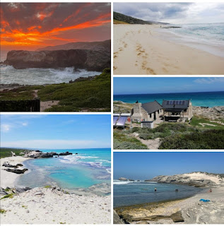

DAY 6:
Vaalkrans to Koppie Alleen
7 km – Easy ± *6 hours (2 hours of actual walking, with 6 hours suggested for several break periods)
This is a short hike through coastal thickets with ample time to soak up the last of the scenic landscapes, there are two alternative routes for high and low tide. Hippo Pools offers great swimming before the path leads up to Koppie Alleen where the trail ends
The group are collected by bus for the 45 minute journey to the start at Potberg where the vehicles are parked.


Mouth watering look at such beautiful hikes! Thank u.
ReplyDeleteGlad you like it!
ReplyDelete