Walking with Giraffes in the Eastern Cape of South Africa close to Addo Elephant National park 🦒 🦒 Simply amazing
Let me know if I can arrange this wonderful experience for you. 🦒🎉

Walking with Giraffes in the Eastern Cape of South Africa close to Addo Elephant National park 🦒 🦒 Simply amazing
Let me know if I can arrange this wonderful experience for you. 🦒🎉
The vast West Coast National Park is a great starting point to experience the raw, authentic, outdoors side of the Western Cape, Endless natural beauty, a string of secret beaches, uncrowded braai spots, loads of exhilarating outdoor adventures, and some of the best wildflower-spotting in the land – these are just some of the wondrous attractions that make this beautifully preserved, unblemished paradise-on-earth the ultimate escape.

Golden Gate Highlands National Park lies at the foot of Lesotho’s Maluti Mountains. Loved for its unusual scenery and renowned for its golden aura as the sun lights up the sandstone cliffs and outcrops. Beautiful hiking trails to explore this lovely area.
Wildlife graze in the wild, grassy pastures, while rare bearded vultures circle the skies above the lost pathways of the San hunter-gathers, who once dwelled in the park's caves. Wildlife in the park includes the black wildebeest, eland, blesbok, oribi, springbok and burchell’s zebra.
Clarence, the most charming little town that the Free State has to offer, next door to the park.

Lesotho 🇱🇸 "land of the Sesotho people, is a high-altitude, landlocked kingdom encircled by South Africa, is crisscrossed by a network of rivers and mountain ranges including the 3,482m-highest peak in Southern Africa, peak of Thabana Ntlenyana.
It is the highest country in the world, the lowest point in Lesotho is 1300 m above sea-level. It has an area of over 30,000 km2 and has a population of about 2 million.
The Sotho ethnic group (also known as Basotho), from which the country derives its name, composes 99.7% of the country's population, making it one of the most ethnically homogenous in the world. Their native language, Sesotho, is the official language along with English.

Blyde River Canyon Reserve is situated against the Greater Drakensberg escarpment and includes natural wonders such as the Bourke's Luck Potholes, the Three Rondavels, Pinnacle Rock and God's Window.
The Blyde River Canyon is 26km long and considered the biggest green Canyon on Earth. Grand Canyon is the biggest, the Fish River Canyon second and the Blyderivier Canyon the rd biggest Canyon overall.

Regyne, the biggest commercial protea farm in the world. Regyne’s protea fields cover 80 hectares and they produce flowers primarily for the export market. Proteas are cut, sorted and trucked straight to the airport for export.
Hanli Viljoen took us on a tour of the farm. We visited one of the fields where they grow King Proteas, South Africa’s national flower. We were educated on how proteas are propagated, either from seeds or cuttings. We also saw the sorting & packing shed where the flowers are prepared, and packed as well as the cold room. Flowers reach their destination in Europe within 48hours!

The Timbavati Game Reserve lays within the Greater Kruger area. It shares a fifty kilometer unfenced border with Kruger National Park. The animals roam freely between the parks. 🦒🐾
Timbavati Game Reserve offers is known for its natural splendor, wide swathe of bush and high density of wildlife - including the Big Five, over 350 bird species and the rare white lion. 🐘🐦⬛
Timbavati had various lodges to choose from. You will find remote, friendly abodes providing the perfect safari home for a family getaway, romantic honeymoon, group trip or whatever else you are seeking. Accommodations come in every price range – starry night skies are complimentary.


Kruger National Park is a South African National Park and one of the largest game reserves in Africa. It covers an area of 19,623 km2 (7,576 sq mi) in the provinces of Limpopo and Mpumalanga in northeastern South Africa, and extends 360 km (220 mi) from north to south and 65 km (40 mi) from east to west.
Areas of the park were first protected by the government of the South African Republic in 1898, and it became South Africa's a national park in 1926. Kruger National Park. The Park was opened to tourism in 1927, only three cars entered the Reserve in the first year.


When food becomes art👨🍳 Marthinus Ferreira and the team pride themselves on using seasonal ingredients, which means the menu changes regularly. Visit Jordan Restaurant at Jordan Wine Estate Stellenbosch to see the magic happening in real life. 😋

The Whale Trail is a must-do if you love hiking and appreciate the outdoors. The trail is suitable for medium-fitness hikers. It is a five day, 56-kilometre slack-packing trail through the De Hoop Nature Reserve that introduces you to some of the most beautiful scenes along the Western Cape coastline. The reserve is part of the Cape floral region and is a World Heritage Site that hosts one of the largest marine protected areas in Africa. Famous for the large pods of whales that congregate during breeding season annually.
Between June and November, scores of the large endangered Southern Right whale, calve close to the shoreline. That being said, the hike itself is just as wonderful when the whales are not present. De Hoop Reserve acts as a nursery to the young whales during breeding season. It is said to be one of the world’s best land-based whale-watching areas. The Southern Right whale spends the summer in the far Southern Ocean feeding close to Antarctica and migrates north in winter for warm-water breeding. If you’re lucky you’ll also see large schools of resident dolphins and seals, as well as sharks in the marine reserve.
Expanses of fynbos, grasses and proteas lie before you every step of the way. The landscape is constantly changing as is the vegetation. The first two days are mountainous and as you move along the coast on the third, fourth and fifth day, the coastal scenery is breathtaking. De Hoop is part of the Cape floral region, which is one of the planet’s smallest, and most threatened floral kingdoms. The reserve is essential in conserving rare lowland fynbos. De Hoop has an estimated 1,500 plant species.

We ascended from Paradyskloof side, Eden Forest. We descended towards Coetzenburg, then back to cars.
The views from the top are amazing. One can see the whole Jonkershoek Valley, Simonsberg, Table Mountain, False Bay all the way to Cape Point. Beautiful Fynbos.
Alternatively one can ascend via Assegaaibos, on the Jonkershoek side or Coetzenburg.
Strenuous hike. Approximately 6 to 7 hours, be prepared with food and water.
Check out my activity on Strava: https://strava.app.link/JvakutpfyAb


Amatola Trail
On the way to start the Amatola Trail enjoy the rural scenery and the cows. The Amatola Trail is widely regarded as the toughest and one of the most amazing hutted hiking trails in South Africa. A six-day and five-night hike starting at Maden Dam near King Williams Town, traversing the incredible Amatola Mountains and ending in the iconic village of Hogsback.
The Amatola Trail is truly amazing. One of the most beautiful hikes I have ever hiked. I consider it as the Comrades of South Africa’s Hiking Trails 👣

Day 1
Maden Dam – Gwiligwili Hut (11km)
Day 1 is the easiest and Day 1 Maden Dam – Gwiligwili Hut (11km) shortest day of the whole trail, and the only day you don’t need to set off at Daybreak. Dan ftom Away with the Ferries will take you to start at Maden dam and then you climb 700m on the first day. You climb through a beautiful indigenous forest You will notice what looks like fresh dog poo everywhere, it’s digested soil, from giant earthworms and they often grow to 1m in length !
Gwiligwili Hut is perched on top of a hill with views forever and beautiful sunset.
Water: Take 1 liter to 1.5 liter of water with you. There are one or two opportunities on way to fill up at streams
Check out my activity on Strava: https://strava.app.link/3iq05nOkiAb

Day 2
Gwiligwili Hut – Dontsa Hut (18km Or 19.6km)
Day 2 Traverse through indigenous forest the entire distance with the Keiskammahoek valley below. It is a long day of undulations which can be exhausting for the less than fit. Dontsa hut is in one of the few patches of pine plantation that you will pass through. Pine on one side and indigenous forest on the other.
Water: Take enough water with. The water in the streams below Hut 2 is not safe to drink
Check out my activity on Strava: https://strava.app.link/ChYJaiTmiAb


Day 3
Dontsa Hut – Cata Hut (20,62 km 2024m Ascent)
This is a very long tough day, with lots of outstanding views. For the first time you leave the forest behind as the trail ascends to the plateau, where macchia grassland and a myriad of wildflowers grow.
Check out my activity on Strava: https://strava.app.link/fMAYwz8miAb

Check out my activity on Strava: https://strava.app.link/KQSzbnaniAb


Day 5 Mnyameni Hut to Hog 3 (19.42km 991m Ascent)
Check out my activity on Strava: https://strava.app.link/WaP0qrbpiAb

Day 6 Hog 3 to Hogsback (16.2km. 1000m Ascent)
Visit Baines Falls, before setting off on last day of the trail. The trail goes up up up 900m (past the dam and water full up) ascent to Hog 1. At top of the climb you are on the edge of Hog 1 from where you can see the whole route you've hiked and forward to Hogsback. Beautiful!
Check out my activity on Strava: https://strava.app.link/0TCPxGvpiAb


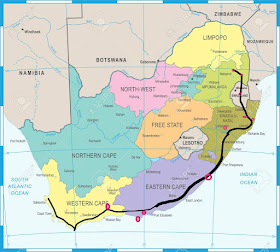
South Africa Tour I will go on a virtual tour through beautiful South Africa during lockdown 2020...